Get the latest info on snow plowing operations using PlowTrax!
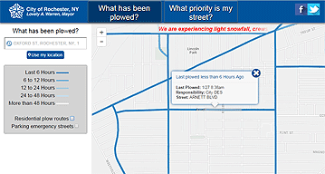
PlowTrax is a web-based map activated during snow events. It uses GPS to track the progress of approximately 150 snow plows and show their current locations. The map is updated every five minutes during snow events.
Go to PlowTrax now!

Features
- Location of each vehicle that is currently in use (look for the truck symbols)
- Date and time the street was last plowed
- Click or tap on the map to zoom in and move the map on the screen
- Enter a street address or click "Use my location" button to zoom to a specific address
- Latest news on the snow event is displayed across the top of the map
- Show the plow routes by clicking "Residential plow routes." This will show the group of streets serviced by each plow truck

PlowTrax is a useful tool for residents, drivers, and City staff. DES managers use this information to make real-time adjustments to plow routes. Customer service agents in the 311 call center are able to provide callers with better information than ever before.