Introduction
The Former Emerson Street Landfill (FESL) is a closed municipal
solid waste landfill located in the western portion of the City of Rochester,
bounded by Lexington Avenue to the north, Lee Road to the west, Ferrano Street to
the south, and Colfax Street to the east.
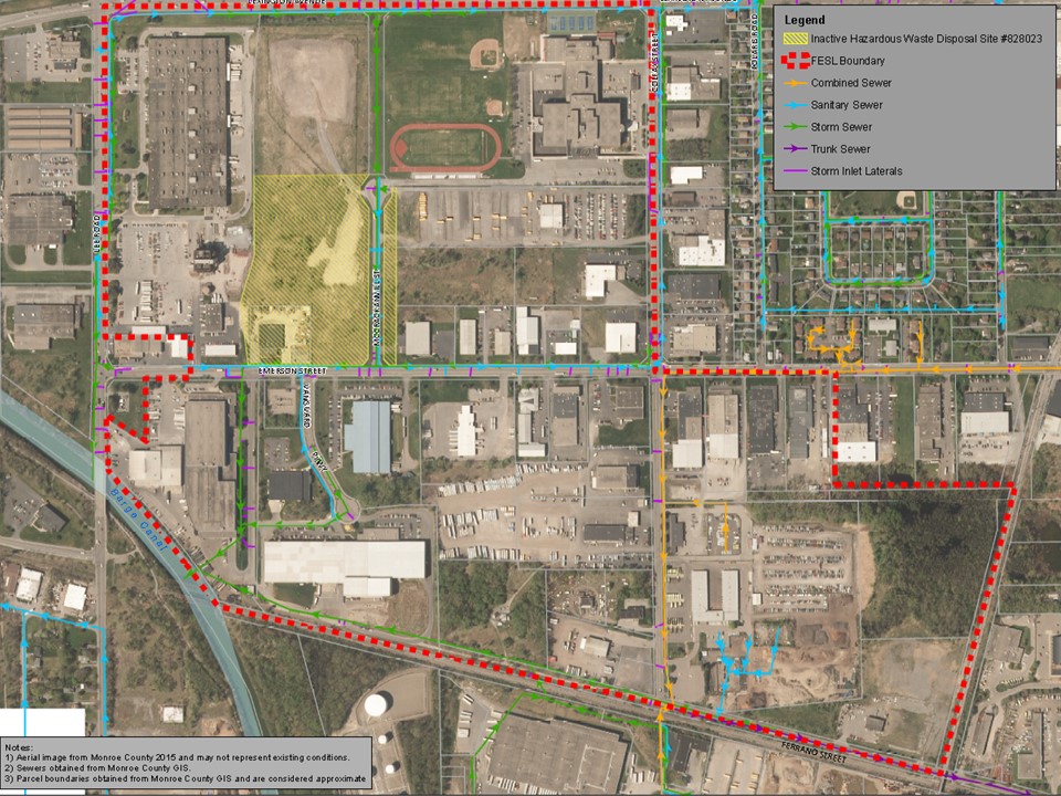
FESL Site Map

History
The FESL was approximately 250 acres in
size operated by the City from about the early 1940’s to 1971 as a landfill.
The landfill was used to dispose of ash derived from the incineration of
municipal waste at the City’s incinerators. Although a majority of the material
placed is ash fill, construction and demolition debris was also placed into the
landfill in some areas. In addition, partially incinerated materials and direct
burial were documented in the later years of operation. Landfilling began south
of Emerson Street and gradually expanded northward and eastward to include
areas between Emerson Street and Lexington Avenue and east of Colfax Street and
south of Emerson Street and generally west of McCrackanville Street.
Fires due to incomplete incineration
and open burning of refuse reportedly occurred in the late 1960s and early
1970s due to operational problems with the incinerators. Fill during this time
frame was reportedly being placed north of Emerson Street. In May of 1971 the
City's incinerators were shut down; however un-incinerated municipal refuse
continued to be placed north of Emerson Street until August of 1971. In August
1971, refuse disposal was ceased at FESL and disposal shifted to a different
county landfill. In 1971 the landfill
was officially closed and a contract for the closure of the eastern half of the
landfill specified two feet of cover material (preferred to be a sandy loam) to
be placed and compacted in one foot lifts. In September 1971, a contract was awarded for
the closure of the western portion of the landfill.
Since closure, portions of the Site have
been developed by various private parties mostly for commercial and industrial
uses; however, Edison Technical School is located on the northeastern portion
of the FESL. A portion of the FESL, (three parcels) which total approximately
15.65 acres, are listed as a NYSDEC Class 3 Inactive Hazardous Waste Disposal Site
(IHWDS), Site #828023, while the remaining parcels within the FESL have been
de-listed. The parcels listed as IHWDS are identified on the Site Map above. A
class "3" classification indicates a site "at which hazardous waste
does not presently constitute a threat to the environment”.
Investigation &
Mitigation
In the 1980s, New York State Department
of Environmental Conservation (“NYSDEC”) began to investigate the FESL. These investigations documented the presence
of petroleum, metals, chlorinated solvents, and 100 cubic feet of radioactive waste
sludge on the southern portion of the FESL which was considered to be a
characteristic hazardous waste due to lead (D008 waste). As a result, the
NYSDEC listed the FESL as an Inactive Hazardous Waste Disposal Site (State
Superfund Site Code #828023). The City
conducted several environmental investigations at the FESL to evaluate
subsurface soil and groundwater conditions across the FESL. Based on these studies, the majority of the
FESL was delisted from the NYSDEC Registry Inactive Hazardous Waste Disposal
Sites (IHWDS).
Most recently, the City has conducted
Soil Vapor Intrusion (SVI) assessments and some limited SVI testing at many of
the properties on FESL. The historic information, subsurface testing and site
reconnaissance results were utilized to develop a conceptual site model and
this was utilized for determining the potential for SVI at each parcel due to
the FESL.
Starting in 2009 the City of Rochester
developed and implemented a Property Owner Soil Vapor Intrusion Technical
Assistance Program for working with property owners in order to assess,
investigate, and mitigate SVI due to VOCs or landfill gases associated with the
Former Emerson Street Landfill. The City of Rochester completed two separate
SVI reports dated June, 2011 and March, 2018. The 2011 report discusses filling
history at FESL, a groundwater investigation, site reconnaissance, methane
evaluation, and all the FESL properties SVI risk assessment ranking as of 2011.
The 2018 report, undergoing NYSDEC and NYSDOH review and approval, details
recent SVI testing conducted at the Former Emerson Street Landfill (FESL). As a result of the SVI assessments at the
FESL, the City developed a Property
Owner Soil Vapor Intrusion Technical Assistance Program that is available to
current and prospective owners in order to address future issues with SVI
associated with the FESL.
The City has also been conducting an updated Remedial
Investigation at 1700 Emerson Street to investigate the extent and magnitude of
chlorinated VOC contamination in soil, waste fill, bedrock and groundwater in
the portion of the FESL referred to as the P-1 Plume area. In preparation of proposing a remedy, the
City has also completed a draft Remedial Investigation report, a Feasibility Study,
and a remedial Pilot Study in the P-1 Plume area. Each of these reports are
undergoing NYSDEC and NYSDOH review and approval.
Further Information
For further detailed information, please refer to the
following documents:
If you have additional questions regarding the FESL please
contact Mr. Joseph Biondolillo, Associate Environmental Specialist, City of
Rochester Division of Environmental Quality email him.