The Rochester region has a long and proud history of trail development for economic, transportation, and recreational purposes. The City of Rochester has played a key role in prioritizing the use of trails in the area by leveraging local, state, and federal resources to develop the 18 mile long Genesee Riverway Trail (GRT). Flanking the Genesee River as it passes through the city- sometimes on both banks- has positioned the trail as a regional asset that connects an array of recreational, historical and cultural attractions, as well as diverse neighborhoods. The GRT also touches other regional trails, making it a connector to the surrounding region, too.
The Genesee Riverway Trail is a designated National Recreation Trail. It is a backbone of both the Genesee Transportation Council’s (GTC) Regional Trails Initiative and the City’s Local Waterfront Revitalization Plan.
About the Project
With the majority of the Genesee Riverway Trail in place, the City continues to look for ways to improve upon existing sections of the Genesee Riverway Trail, fill gaps in connectivity, and provide linkages to other trails, neighborhoods, business centers and attractions. 
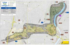
This planning and preliminary design study will develop recommended trail layouts and improvement plans, with an exploration of alternatives, property acquisitions/easements, and corresponding estimates, for two interrelated but distinct trail segments. With the completion of this study, the City intends to immediately seek funding for final design, property acquisition, and construction of improvements for the following trail sections:
- The Eastman Trail: a proposed trail through the Eastman Business Park representing a significant east/west connection between the City’s Genesee Riverway Trail at Kings Landing and the State’s (planned) Route 390 Trail in the Town of Greece.
- The Genesee Riverway Trail between Kings Landing Cemetery and Turning Point Park: this section is currently mostly on-sidewalk within busy street right-of-way with a portion on private property through an easement. The study will look to relocate the trail from the busy street area to the gorge edge and to upgrade the off-road segments, bringing them up to current standards.
This project is being funded with Federal planning funds through the GTC’s Unified Planning Work Program (Task #6524).
Essential Documents
Final Planning & Preliminary Design Report – January 2013
Questions?
For more information about the project, please contact the City's project manager:
Jeffery J. Mroczek, R.L.A., Landscape Architect
Department of Environmental Services, Development Division
30 Church Street Room 300B
Rochester, New York 14614-1279
(585)428-7124
MROCZEKJ@cityofrochester.gov